Barndominium Builders in Craighead County, AR
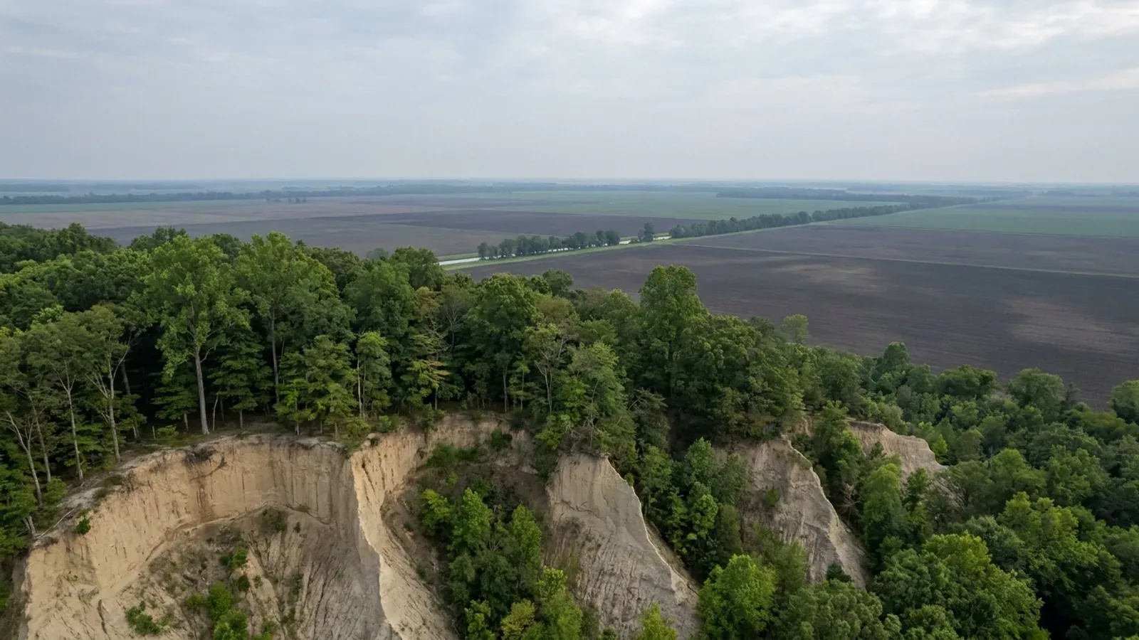
Craighead County is two different building problems inside one county line. Crowley's Ridge crosses it north to south — 165,670 acres of wind-blown loess with real slope on it — and the other 291,130 acres are dead-flat Mississippi River alluvium with the water table a foot below the surface in places. The county government itself does not referee any of it: its codified Code of Ordinances contains a chapter called Urban / Rural Development whose Building article consists of the single word "Reserved." What changes across the county is not the paperwork but the ground and the ground motion, and both change enormously.
Craighead County at a glance
- County
- Craighead County
- Population
- 116,957
- ZIP codes
- 72401, 72404, 72405, 72411, 72414, 72416, 72417, 72419, 72421, 72427, 72437, 72447, 72467
- Site visits
- Craighead County runs about forty miles from the Cache bottoms on its western edge to the Missouri-line ditches past Monette, and both ends of it fall inside our regular northeast Arkansas rotation, so meeting a landowner on a wooded ridge tract near Bono and meeting one on flat ground east of Lake City are equally ordinary bookings.
Building conditions in Craighead County
The State's code reaches every parcel in Arkansas, including rural and unincorporated land. What is not everywhere is the office that checks it: a city or county is authorised to set up a building department, not required to, and a great deal of rural Arkansas never has. So the first question on any parcel is not what the code says — that part travels — but whether anyone here issues a permit, inspects the work, or publishes the design criteria your drawings still have to satisfy. Where nobody does, the obligation does not go away. It just moves to the appraiser, the insurer, your lender and whoever buys the place from you.
https://library.municode.com/ar/craighead_county/codes/code_of_ordinances
Also worth knowing before you build in Craighead County
- Four percent of Craighead County is rated "not limited" for a house — and none of it is on the ridge
- The NRCS publishes an engineering interpretation called Dwellings Without Basements, which rates each soil map unit for a dwelling on a shallow footing. Summed by acreage across survey area AR031, Craighead County comes out at 301,020 acres rated "very limited" (65.9 percent of the county), 132,320 acres "somewhat limited" (29.0 percent), 5,180 acres of water, levee and dam not rated, and just 18,280 acres — 4.0 percent — rated "not limited." Every acre of that 4 percent is Dubbs or Beulah, and both are Delta soils, not ridge soils. The Official Series Description for Dubbs places it "on natural levees or low terraces along former channels of the Mississippi River and its tributaries," says these soils "generally are not flooded and the seasonal water table is below six feet," and rates them well drained with moderate permeability. Beulah sits in "old natural levee positions along bayous, oxbows and abandoned channels" and is somewhat excessively drained. The county's best ground for a slab is a buried river levee out in the flat, not the high ground everybody points at.
- A quarter of Crowley's Ridge in this county is flood-prone valley bottom
- The intuition that the ridge is the dry half of Craighead County does not survive the soil map. Of the 165,670 ridge acres, 44,200 are mapped as flooding occasionally — 22,200 acres of Collins silt loam, 19,130 of Falaya silt loam and 2,870 of Tichnor silt loam, all with the phrase "occasionally flooded, brief duration" in the map unit name. Against that, the whole Delta half of the county carries 18,940 acres in frequently flooded phases of Sharkey, Mhoon and Commerce. So roughly seventy percent of the county's occasionally-or-frequently-flooded soil acreage lies inside the loess upland, in the drainageways the ridge cut for itself. The Collins Official Series Description is explicit about where it sits: "nearly level soils on flood plains and in drainageways in the Southern Mississippi Valley Silty Uplands Major Land Resource Area," formed in "silty alluvium derived from loess," and "subject to flooding for brief to very long duration." Falaya's description puts the water table "within 20 inches of the surface during periods of high rainfall." On the ridge, the high ground and the low ground can be four hundred yards apart.
- The largest single soil on the ridge side of the county is a poorly drained flat, not a slope
- Calhoun silt loam covers 25,730 acres of Craighead County — more than any Loring or Memphis map unit, and the biggest single unit inside MLRA 134. Its Official Series Description classes it as a fine-silty, mixed, active, thermic Typic Glossaqualf sitting "dominantly on nearly level areas and depressions on Pleistocene terraces," formed "from loess or loess-like material more than 5 feet thick," and describes it as "poorly drained; slow to very slow runoff; very slow internal drainage; slow permeability." SSURGO gives it an annual minimum water table depth of 31 centimetres — about a foot — and rates it very limited both for dwellings and for septic absorption fields. Henry silt loam adds another 14,880 ridge acres at a 15-centimetre water table. Meanwhile only 56,410 acres of the county, 12.3 percent, carry a dominant slope of five percent or more, and every one of those acres is inside MLRA 134. The ridge is not uniformly steep and it is not uniformly dry; a third of it is sloping upland and most of the rest is flatwoods and valley floor.
- Not one acre in Craighead County is rated "not limited" for a septic drainfield
- Running the NRCS Septic Tank Absorption Fields interpretation across the same survey area returns no "not limited" acreage at all. The best the county offers is "somewhat limited," and that covers 72,270 acres — 15.8 percent — spread over Hillemann silt loam, Dubbs silt loam, the 3-to-8-percent and 1-to-3-percent Loring phases, both Calloway phases and Grenada silt loam. Everything else, 379,350 acres or 83 percent of the county, is rated very limited. The reasons differ by half of the county and that matters for how a system gets designed: on the ridge it is a fragipan and, on the steeper Loring and Memphis phases, slope — Loring silt loam at 8 to 12 percent is rated only somewhat limited for a dwelling but very limited for a drainfield, purely on grade. In the Delta it is a water table that comes within 13 to 15 centimetres of the surface under Jackport, Foley, Amagon and Henry, and sits at the surface under Sharkey clay. On a rural Craighead County site the septic design is usually the constraint that sets where the house can go, not the footing.
- Lake City requires a permit for a dog pen, charges seven cents a square foot, and pays its Building Inspector $600 a year
- Lake City is the county's eastern seat and its fastest-growing town, and Title 11 of its municipal code is the most granular permit ordinance in the county. Section 11.08.01 requires a building permit for a single-family residence, a multiple-family residence, any commercial building, "any storage shed, storm cellars, workshop, swimming pools, playhouse or garage," "any fence or dog pen," and any addition or alteration to those. Section 11.08.08 sets the price: $5.00 for a fence or storage shed measuring 8 by 10 feet or less, and "the fee on any other structure or addition will be figured at $.07 per square foot." A permit lasts six months. Section 11.08.02 re-establishes the office of Building Inspector, appointed by the Mayor with Council approval, who "shall be paid an annual salary of Six Hundred Dollars," and section 11.08.03 requires that he "reside within the city limits and have a telephone." The application at 11.08.07 asks for the construction materials of the foundation, floor and exterior walls, "the manner in which the proposed building will be anchored to the foundation," and the height of the first floor above ground level both before and after grading — a floodplain town's questions, written into a building form.
- Brookland rewrote its zoning code in December 2025, and it caps a detached shop at 800 square feet
- The City of Brookland adopted a new Zoning Code by Ordinance #2025-26 on 9 December 2025. Section 8.03.0 sets the A-1 Agricultural / Rural Residential district at a one-acre minimum lot with no minimum width, 25-foot front, side, side-street and rear setbacks and a 45-foot height limit; single-family homes, manufactured homes, agriculture, home occupations and churches are permitted there by right. Section 9.01.1(E) is the line a pole barn build runs into: "Accessory buildings exceeding eight hundred (800) square feet in area or forty percent (40%) of the gross floor area of principal building on the lot, shall require a conditional use permit." Section 9.01.1(D) requires ten feet between a detached accessory building and the principal building unless the accessory carries a one-hour fire-rated wall. Section 9.01.2 permits one accessory dwelling unit by right on a lot with a larger existing single-family house, capped at 75 percent of the principal dwelling or 1,000 square feet, whichever is less, with a review fee of $250 where the Council's schedule does not set one. Section 3.04.0 makes it unlawful for any utility to connect service to a building without a certificate of occupancy.
- All of the county's growth is inside a city limit, and the unincorporated balance is shrinking
- The Census Bureau's Vintage 2025 sub-county estimates carry a row for "Balance of Craighead County" — everything outside every municipal boundary. It went from 18,734 at the 2020 base to 18,075 on 1 July 2025, a loss of 659 people, while the county as a whole gained 5,715 to reach 116,957. Every one of those net new residents is inside a city limit. The gains are concentrated: Lake City grew 20.8 percent to 2,796, Bono 18.7 percent to 2,858, Brookland 15.5 percent to 4,697 and Monette 11.4 percent to 1,679, against Jonesboro's 6.1 percent. The far end of the Delta went the other way — Bay fell to 1,803, Caraway to 1,104, Cash to 280, Black Oak to 261 and Egypt to 108. The practical reading for a land search is that the three towns absorbing rural demand in this county are Brookland and Bono on the ridge and Lake City just off it, and all three of them run a permit counter that the surrounding countryside does not.
- Split five acres or more for agriculture out here and it is not a subdivision at all
- Section 1200.00(4)(a) of the Craighead County code defines a subdivision as "a division of land into two (2) or more lots or parcels, including the combination or recombination of two (2) or more previously plotted lots," and then carves out the case most rural buyers are actually in: "any division of land for agricultural purposes, into lots or parcels of five (5) acres or more, shall not be deemed a subdivision unless street dedication or the installation of utilities are involved." Anything that does count runs three steps — a concept plan to the County Judge, then eight copies of a preliminary plat with one set of detailed construction plans distributed to the Quorum Court Road Committee for a decision within thirty days, then a final plat and bond filed with the Circuit Clerk. The County Judge may consult an independent registered professional engineer, at county expense for the first consultation and at the developer's expense for a full analysis, with "preference … given to engineers located within one hundred (100) miles of the County." The ordinance also bars using metes-and-bounds conveyances to sidestep it. Ordinance 2006-017, passed 12 December 2006, amended by Ordinance 2019-013, passed 26 June 2019.
- An 18-inch driveway tile and a three-inch house number are the two county rules a rural build actually meets
- The county's road standards at section 1200.00(9)(a) are short and specific: "18 Inch Minimum diameter on driveway tiles"; an 80-foot turnaround on dead-end roads with 15 feet of right of way outside the circle of the cul-de-sac; "Reinforced concrete pipe culverts will be used under all County Roads"; every new road must carry a 911 address; a new subdivision road meeting a hard-surfaced road must itself be hard-surfaced; and a utility cut in a county hard surface needs the County Road Superintendent's approval. Before the county will adopt a road for perpetual maintenance the developer posts a maintenance bond of fifty percent of actual construction cost for one year, and fifty percent of the lots must have houses built on them. Section 1200.01 then handles addressing: numbers at least three inches high, no script, on the Equal Interval Addressing System, and "premises on which buildings are being constructed shall post street numbers prior to beginning construction." A first offence carries a fine of not less than $25.00.
- Every community in the county went onto a new flood map on 26 September 2024
- FEMA's Community Status Book for Arkansas lists eleven participating communities in Craighead County — the county itself under CID 050427, plus Bay, Black Oak, Bono, Brookland, Caraway, Cash, Egypt, Jonesboro, Lake City and Monette — and all eleven carry the same current effective map date of 09/26/24. A countywide map revision that recent means an elevation certificate, a lender's flood determination and any prior survey may all be reading from different vintages of the same parcel. The county's own Regular Program entry date is 20 December 1993, which lines up with its flood ordinance: section 280.00 of the county code adopts a flood damage prevention regulatory code by reference under A.C.A. 14-268-101 to 14-268-105, Act 629 of 1969, by Ordinance 1993-017 passed 25 October 1993 and amended in 2004 and 2007, and states that "a copy of the referenced regulatory code shall be filed in the office of the County Clerk." Two of the eleven communities are in FEMA's Community Rating System: Jonesboro at Class 8 with a ten percent premium discount, and Bono at Class 10.
- West of Crowley's Ridge this county is inside a designated Critical Groundwater Area, and the ridge is the reason it stops there
- The Cache River Watershed-Based Management Plan, prepared for the Arkansas Natural Resources Commission by FTN Associates and dated 21 November 2016, records that "In 2009, the portions of the Cache River watershed in Clay, Greene, Craighead, Poinsett, and Cross Counties, west of Crowley's Ridge, were designated part of the Cache Critical Groundwater Area," for both the Mississippi River Valley alluvial aquifer and the Sparta/Memphis Sand aquifer. The same plan measures the decline: "Average water level declines in the upper Cache River watershed over the last 10 years range from 4.45 ft in Clay County to 9.21 ft in Craighead County" — the largest figure the plan names for that watershed — and reports that in spring 2014 depths to water in the alluvial aquifer under the upper Cache watershed "ranged from less than 17 ft to over 94 ft." The hydrogeology explains the boundary: "Crowley's Ridge acts as a barrier to flow in the MRV alluvial aquifer from the east side of the ridge to the west side." A domestic well on the west side of this county is drawing from a declared and declining resource; on the east side it is not.
- The state's landslide inventory for the ridge exists, catalogues 52 sites, and has never been digitised
- The Arkansas Geological Survey's catalogue entry for Information Circular IC-31, "Landslide features of Crowley's Ridge" by J. D. McFarland III, 1992, describes a ten-page report with two figures and seven tables. Its contents are listed as a map of the location of studied landslides, "Graphs of Atterberg limits for loess samples collected from the study area," a precipitation graph for the first five months of 1991, a "Table of landslide site locations with site number, county, quadrangle map name, UTM location, and type of landslide (slide, flow, fall, creep)," a discussion of potential hazards, and an appendix of "site descriptions of 52 representative landslide locations in the study area." A paper copy is $5.00 from the Survey's sales office; the online version is a 7.58 MB scanned PDF with no searchable text layer. That the state's only landslide inventory for this ridge distinguishes slides from flows from falls from creep is the useful part: the failure modes in loess are not one thing, and a cut bank on a Craighead County ridge parcel is a geotechnical question rather than an earthmoving one.
https://lakecityar.com/Assets/Files/CodeEnforcement/Codification-Title-11.pdf
https://www2.census.gov/programs-surveys/popest/datasets/2020-2025/cities/totals/sub-est2025.csv
https://media.ark.org/agri/Cache-WMP-Final-Accepted-2016.pdf
https://geology.arkansas.gov/publication/information-circulars/IC-31-information-circular.html

The expensive surprises are in the ground, not the building
What moves an Arkansas budget is usually below grade, and the state hands you a different problem depending on where you stand. In the Delta the issue is shrink-swell clay that moves with the season, and it is the reason a wide, light building with a big slab and a big door opening is the shape most at risk. Along the Fall Line there is a second, separate clay belt with nothing to do with the Delta at all. Up in the Ozarks the question inverts: what matters is not what the slab sits in but what is under it, because that limestone is full of solution cavities and the collapses arrive with no prior indication at the surface. And on Crowley's Ridge, where Jonesboro and Paragould sit, it is fine wind-blown loess that stands up in a vertical cut and then erodes out from under whatever you put on it. The same ground decides your wastewater system, which is the gate that most often moves a rural build's schedule — and it is soils that decide it, not the size of the house. So the site work, the foundation and the wastewater get resolved together rather than one at a time. We price the dirt before we price the building.
What we build in Craighead County
All nine services are available in Craighead County. What a build costs depends far more on the parcel than on square footage, so we price against your land rather than publishing a rate card.
Custom Barndominium Plans
Barndominium floor plans, elevations and engineered documents drawn to your parcel — and to the design numbers your Arkansas jurisdiction publishes.
Barndominium Kits
Engineered barndominium shell packages for Arkansas land, drawn to a named jurisdiction's criteria rather than to a national vendor's generic spec.
Turnkey Barndominium Builds
Land through handover under one contract, and a straight answer on what actually gates a barndominium build on rural Arkansas land.
What a build looks like
Three stages every Craighead County project passes through, from a raw parcel to a finished home. Site work first, because that is where the budget is decided.

The parcel
Zoning, setbacks, flood zone and utility access get checked before anything is drawn.
Pad and permit
Clearing, grading and a compacted pad, while the submittal works through whichever office issues the permit where you are building.

Frame to finish
Shell erected and dried in, then systems, insulation and interior finish through to CO.
Those are the rules where you are building in Craighead County. Tell us what you want to build and we will draw it to them.
Where we build around Craighead County
Craighead County and the rural land around it. The buildable acreage for a project this size usually sits outside the city limits, which is frequently what changes who issues your permit.
Keep reading
The questions that usually come next once you know what Craighead County allows.
Barndominium Cost Guide
Sourced per-square-foot ranges by tier and by size, with a calculator built on the same figures.
Read itThe Arkansas Building Code
The code applies statewide, including unincorporated land — but a jurisdiction is only authorized to establish a building department, so on rural residential land there is often no counter at all.
Read itBuying Land in Arkansas
Where acreage is actually purchasable in homesite sizes, and what percolation, slope and the onsite wastewater rule do to a parcel before anything is designed.
Read itNearby areas we build in
Others we cover nearby. One may be a county, another a city inside it — and since March 2025 the soft edge between them is gone, because the cities' extraterritorial jurisdiction was abolished outright and that land reverted to the counties. So the office that issues the permit, the fees it charges, the zoning and whether anyone publishes design criteria at all can differ from one card to the next, and the boundary that decides it may have moved recently.
Building in Craighead County: common questions
9 questions we get asked most often about building in Craighead County. If yours is not on the list, ask it directly.
Do I need a building permit to build a barndominium in unincorporated Craighead County?
Which towns in Craighead County actually issue permits, and what do they charge?
Crowley's Ridge or the Delta — which side of the county should I buy on?
Is my land really in Seismic Design Category E, and what does that change?
What about water — can I put a well in out here?
Do I have to plat if I split a homesite off a farm?
How do I check flood risk on a Craighead County parcel?
Where in Craighead County can I actually buy a homesite?
If nobody inspects the build, what standard is my barndominium actually held to?
Building in Craighead County?
Start with the plan. Tell us what you want to build and we will draw it, then confirm which office issues the permit for your parcel, what it will let you put there, and what wind load it has to meet. That conversation costs nothing.