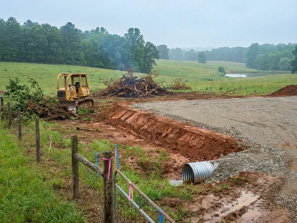
A dozer clearing brush on a rural parcel beside a compacted crushed-stone building pad, with red clay exposed in the cut and a culvert set at the driveway entrance.

Site Preparation in Arkansas

Site preparation is the access and the driveway, clearing and grubbing, cut and fill, the compacted pad, drainage away from the building and the culvert — everything that has to be right before the first anchor bolt goes in. It is also the point at which an Arkansas parcel tells you what it is going to cost, because the ground changes completely across the state: shrink-swell clay through the Delta and along the Fall Line, karst under the Ozarks, wind-blown loess on Crowley’s Ridge, shallow rock through the Ouachitas, and three major river systems. A barndominium is wide, light and slab-dominated, which makes it the least forgiving building type there is on ground that moves.

Permit-ready stamped drawings
Engineered to the code, whether or not anyone inspects

How a site preparation project runs

Four stages, in this order. The sequence matters more than it looks: getting engineering and permitting settled before anything is fabricated is what keeps a build from stalling.

1

Read the ground before anything moves

Boundary and topographic survey first, then the soil, before an excavator is booked. USDA-NRCS Web Soil Survey lets a landowner draw their own parcel and get the mapped soil series back, which is how you find out whether you are on Sharkey, Perry or Jackport clay, on a fragipan that perches water every winter, or on rock within four feet of the surface. On a rural tract the onsite wastewater approval is an early gate on the whole project and the soils are what decide it, so that evaluation runs alongside the survey. It is a named, physical procedure rather than a formality: the Arkansas Department of Health’s onsite wastewater rule requires at § 7.1 a minimum of two soil pits, one in the proposed primary absorption area and one in the secondary, dug to four feet unless an impervious layer stops them and left open for the county Authorized Agent to look at. The person who does that work and completes Part I of the permit application is a Designated Representative, a private licensee the landowner hires and the Department lists in its own public lookup — and only a Soil Qualified Designated Representative may size a system from seasonal water table data. Clearing first and learning about the soil afterwards is the most expensive order available on this building type.

2

Access, clearing and grubbing

The driveway comes before the building, because everything else arrives on it — concrete trucks, the crane, the panel loads. Where the drive meets a county or state road, the entrance and its culvert are the road authority’s decision and the pipe is sized to the ditch it interrupts. Then vegetation and stumps come out, with organic material grubbed from under the pad footprint rather than buried in it. On Crowley’s Ridge the timing matters more than elsewhere: Hubert Stroud, writing for the Encyclopedia of Arkansas, records that the ridge’s wind-blown soils need a protective vegetative cover such as pasture grass or forest to combat severe soil erosion.

3

Cut, fill and the compacted pad

A barndominium is wide, so it needs more pad than most people expect, and the pad has to run well past the slab edge on all four sides to give the fill somewhere to stand. Cut and fill are balanced on the parcel where the topography allows, because importing or exporting material is the line that moves the earthwork budget. Fill goes down in lifts and is compacted to a tested specification — engineered fill under a slab, never spoil. One code detail sets the datum: R403.1.4 requires exterior footings to be placed not less than 12 inches below the undisturbed ground surface, and R403.1.1 sizes footing width and thickness against the soil’s load-bearing value from Table R401.4.1.

4

Drainage, the culvert and the utility runs

Water is routed away on every side and given somewhere to go that is not the neighbour’s field: a crowned pad, perimeter swales, an interceptor ditch upslope where the ground falls toward the house, and culverts set at the flowline of the ditch they cross. Where the site is in a mapped Special Flood Hazard Area and the community participates in the National Flood Insurance Program, a Floodplain Development Permit comes before construction begins and an Elevation Certificate is certified by a licensed land surveyor or engineer. Power, water and the wastewater system then run to the pad, and where a private well is part of the plan its position is fixed by rule rather than by convenience. The Arkansas Water Well Construction Rules, administered by the Arkansas Natural Resources Commission in the Department of Agriculture, put the well 100 feet from a septic tank at 17 CAR § 11-502(c) and double that in highly pervious gravel formations, while the Department of Health’s onsite wastewater rule § 5.2 adds 50 feet from any lot line and 100 feet from any part of a wastewater system on this lot or an adjacent one. A ground-source heat pump loop is caught too: § 11-502(e) keeps it 50 feet from a septic tank, its field lines or a drinking-water well, waivable only in writing before construction.

An excavator grading a compacted building pad on a cleared lot, with survey stakes and a drainage swale visible.
What the ground decides

Arkansas has two separate expansive-clay problems, and they are in two different places

The Arkansas Geological Survey’s expansive-soils page names one of them: the Porters Creek Clay of the Midway Group, outcropping in a narrow but continuous belt along the Fall Line from just south of Hope to near Arkadelphia, and intermittently from Malvern to near Batesville. The Survey’s own framing is that these clays shrink and swell with moisture content, and that where that is not considered during construction, structures such as houses can literally break apart. That belt is not the Delta. Query the federal soil survey and the second, larger problem appears: USDA SSURGO, at the Arkansas data version of 9 September 2025, puts Vertisols — the soil order defined by shrink-swell — under 43.6 percent of the Chicot survey area, 34.8 percent of Desha, 33.7 percent of Crittenden and 30.7 percent of Mississippi County. The series doing the work are Sharkey, Perry and Jackport, and Perry was established in Perry County, Arkansas in 1920. Both findings are real, they are different mechanisms, and neither one appears on any competing Arkansas barndominium page.

Where we deliver site preparation

In Arkansas the city limit is a real boundary rather than a formality, and since March 2025 it is a harder one: Act 314 abolished the cities’ extraterritorial jurisdiction outright, so the one-, two- and three-mile rings that used to reach out from Fayetteville, Springdale, Rogers, Bentonville, Conway, Jonesboro, Fort Smith and Little Rock are gone. Inside a city that has established a building department you get review, fees and inspections. Outside one you frequently get nobody — and county zoning only exists where a county first created a planning board. The code applies on both sides. The person checking it may not.

Serving clients across the entire region.

Every locality we build in has its own reviewer, its own fee schedule and its own filled-in design criteria. The service area pages set out what each one publishes.

View our full service area →
Before you commit

What actually decides the price

Square footage is the number everyone leads with, and it is rarely the one that moves a barndominium budget. These four do.

  • Which clay is under the pad

    Two independent sources, two different places, and your parcel is in one, both or neither. The Arkansas Geological Survey names a Fall Line belt of Porters Creek Clay running Hope to Arkadelphia and Malvern to Batesville. USDA SSURGO puts Vertisols under 43.6 percent of the Chicot survey area, 34.8 percent of Desha, 33.7 percent of Crittenden, 30.7 percent of Mississippi, 25.2 percent of Monroe, 24.1 percent of Poinsett and 21.2 percent of Phillips. Where the answer is yes, the pad build-up, the fill specification and the slab all stop being standard details.

  • Rock in the Ouachitas, nothing to bear on in the Delta

    SSURGO records a bedrock restriction within 152 cm under 79.7 percent of the Cleburne survey area, 79.0 percent of Van Buren, 70.8 percent of Garland, 70.3 percent of Perry, 69.2 percent of Polk, 67.5 percent of Montgomery and 65.1 percent of Scott — where the budget line is rock excavation for footings, trenches and the drainfield rather than soil bearing. Shallow rock is also what decides the septic answer, and Arkansas sets no minimum lot size for a conventional system: the Department of Health’s rule asks at § 4.2 and § 5.3 for a suitable primary absorption area and a suitable secondary one, both meeting its setbacks and both sized from the natural soil, and it refuses approval regardless of lot size where the soil will not renovate wastewater at all. It returns 0.0 percent for Chicot, Crittenden, Cross, Desha, Mississippi, Phillips, Poinsett, St. Francis and the rest of the Delta: the opposite problem, deep soft ground with nothing shallow to found on.

  • How much earth has to move, and how far

    A 60 by 40 shop-house spans more soil variability than a compact two-storey house of the same floor area, and the pad has to be bigger than the footprint on every side. Four things then set the earthwork package: whether cut and fill balance on the parcel, how far material is hauled if they do not, how long the driveway is, and what the entrance culvert has to span. On the ridge and in the mountains the topography drives it; in the Delta it is the fill height needed to get the finished floor where it has to be.

  • Where the water goes, and whether a map says flood

    Arkansas is defined by the Mississippi, Arkansas and White river systems, and floodplain management here is run by the Natural Resources Division of the Arkansas Department of Agriculture, which coordinates the National Flood Insurance Program for the state. Community participation in the NFIP is voluntary, and the Department states that 424 Arkansas communities participate — so whether your land is in a mapped flood hazard area and whether anyone locally administers a permit for it are two separate questions. Drainage design, fill volume and finished-floor elevation all follow from the answers.

A dozer clearing brush on a rural parcel beside a compacted crushed-stone building pad, with red clay exposed in the cut and a culvert set at the driveway entrance.

Site Preparation in Arkansas: common questions

9 questions we get asked most often about building in Arkansas. If yours is not on the list, ask it directly.

How can I tell whether a parcel has expansive clay before I buy it?
Start with USDA-NRCS Web Soil Survey. It is free, it is the public face of the same SSURGO database the figures on this page come from, and it lets you draw your own parcel boundary and get back the mapped soil series with their properties. What you are looking for is a Vertisol — the soil order defined by shrink-swell, which cracks deeply when dry and closes those cracks when wet. In eastern Arkansas the names to watch for are Sharkey, Perry, Jackport, Alligator and Portland; along the Red River, Billyhaw and Bossier; and in the southwest, Oktibbeha, Wilcox, Billstown and Houston, mapped in Hempstead, Clark, Howard, Nevada, Pike, Sevier and Bradley. That southwestern group matters because it is independent confirmation: the Arkansas Geological Survey reached the same ground from bedrock geology, naming a Porters Creek Clay belt from just south of Hope to near Arkadelphia and intermittently from Malvern to near Batesville, while the federal soil survey reached it from soil taxonomy. Two methods, the same counties. The Ozark counties come back clean on this measure — Baxter, Benton, Boone, Carroll, Fulton, Independence, Izard, Madison, Marion, Newton, Searcy and Stone all return 0.0 percent Vertisol — though they carry a different problem entirely. Treat the map as a screen, not a verdict: a mapped series is a polygon drawn at survey scale, and a boring at the actual pad location is what confirms what is under your building.
What does shrink-swell clay actually do to a barndominium slab?
The numbers come from the soil series descriptions themselves. Sharkey, the most widespread expansive series in Arkansas at over 900,000 acres, is described with a COLE of about 0.10 to 0.17 through its subsoil — meaning the soil changes length by ten to seventeen percent between wet and dry — and with 60 to 90 percent clay in the 10 to 40 inch control section. In most years it opens cracks one to three centimetres wide to a depth of 20 to 24 inches or more. Those cracks are not a defect; they are the normal summer condition of that soil, and they close again in winter. Perry, established in Perry County, Arkansas in 1920 and mapped through the Arkansas and Red River backswamps, runs 60 to 85 percent clay with montmorillonite dominant. That clay is a wastewater problem before it is ever a slab problem: the Department of Health’s onsite wastewater rule publishes no soil loading rates at all above 60 percent clay at § 7.3.5, and § 8.5.2.2 treats a percolation rate slower than 75 minutes per inch as unsuitable for a standard system. A fast percolation result cannot rescue a wet site either — § 8.5.2.3 says an absorption area sized on percolation data may not be smaller than seasonal water table data would require for the same ground. Now put a barndominium on it. It is wide, and differential heave scales with plan dimension. It is light, so a post-frame or steel shell puts a fraction of a masonry house’s dead load on the clay and there is less weight resisting swell. It is slab-dominated, so the floor is the foundation over most of its area and soil movement shows up directly as floor movement, with no crawl space to absorb it. And it usually has a large opening in one wall, and an overhead door is the least tolerant element in the building of a racked frame. The Arkansas Geological Survey’s own wording is that where this is not considered during construction, structures such as houses can literally break apart. Worth knowing: the Survey lists no Arkansas expansive-soil case studies at all, so treat any specific damage statistic you are quoted with suspicion.
Is sinkhole risk real on Ozark land, and how does it differ county to county?
It is real, it is concentrated, and it has been counted. A 2016 U.S. Geological Survey data release by Turner, Knierim and Kresse digitised springs and sinkholes across the Arkansas Ozarks from more than 200 topographic quadrangles published between 1942 and 2014, across 22 counties, recording 805 springs and 1,242 sinkholes. By county the mapped counts run Benton 332, Washington 165, Sharp 100, Baxter 86, Searcy 77, Carroll 69, Boone 69, Newton 65, Marion 65, Stone 49, Independence 44, Izard 36, Fulton 25 and Madison 21. Benton and Washington, the two fastest-growing counties in the state, hold about forty percent of every sinkhole USGS mapped. Angela Chandler of the Arkansas Geological Survey, writing in the Encyclopedia of Arkansas, records that the Boone Formation limestone under the Springfield Plateau contains the majority of the region’s karst features and more than half the caves in the state, that the Salem Plateau dolostones hold about twenty percent, and that the Boston Plateau surface, being Atoka sandstone and shale, is not susceptible to karst features — so Boston Mountain land is a genuinely different proposition. The failure mode is what matters on site: the Survey’s land subsidence page describes clay-rich overburden bridging a subsurface cavity for long periods before collapsing into it, and says a cover-collapse sinkhole usually develops in a short period of time with no prior indication of its pending existence, especially during extreme groundwater fluctuations after prolonged wet and dry periods. Two cautions. These are mapped sinkholes, a floor rather than a risk map. And shallow-bedrock data is not a karst proxy: SSURGO records a restriction under only 5.7 percent of Benton County, because Boone limestone weathers to a deep cherty residuum, in the county with the most mapped sinkholes in Arkansas. Compare Faulkner County, in the Arkansas River Valley — 52.7 percent shallow bedrock, 31.5 percent fragipan, Perry-series clay in the slackwater areas, and no entry in the Ozark sinkhole dataset at all. In Benton or Carroll you are pricing voids; in Faulkner you are pricing rock and perched water.
What is different about building on Crowley’s Ridge?
Crowley’s Ridge is geologically unlike anything around it, and Jonesboro, Paragould, Wynne, Forrest City and Helena-West Helena all sit on it. Hubert Stroud, writing for the Encyclopedia of Arkansas, describes a ridge one to twelve miles wide running from southern Missouri across eastern Arkansas, rising some 250 feet above an otherwise flat landscape, with wind-blown loess up to fifty feet deep in places — and because loess erodes very easily, steep slopes and deep valleys characterise much of it. Thomas Foti, in the same reference, puts the relief at generally less than 200 feet, notes the ridge is capped with river-deposited sand and gravel over older Tertiary marine deposits, and states plainly that because of the chemical and physical properties of loess, landslides are common where it is thick. The Arkansas Geological Survey published a study of exactly this: Information Circular IC-31, Landslide features of Crowley’s Ridge, by J.D. McFarland III, 1992, whose appendix carries site descriptions of 52 representative landslide locations. Three consequences follow. The slopes are real and the material is weak — the Memphis silt loam series capping the ridge is mapped on slopes from 0 to 50 percent, and loess stands in near-vertical faces when dry and fails when wet, so a cut-and-fill pad here is a geotechnical decision rather than an earthmoving one. The fragipan soils below the crest, Loring, Grenada and Calloway, perch water above themselves through late winter and spring; SSURGO puts a fragipan under 38.1 percent of Lee, 32.9 percent of Cross, 32.8 percent of St. Francis, 24.6 percent of Greene, 24.1 percent of Poinsett, 20.6 percent of Phillips, 20.3 percent of Craighead and 14.0 percent of Clay. And erosion is continuous rather than an event, so bare ground needs cover. Around Jonesboro three ground conditions sit within a few miles of each other: loess ridge with slope and fragipan, Western Lowlands terrace to the west carrying Jackport Vertisol, and the St. Francis Basin to the east carrying Sharkey. Any single answer about soil in Craighead County is wrong somewhere.
Is there a slope above which Arkansas requires engineering?
No, and anyone who gives you a statewide percentage is repeating another state’s ordinance. The Arkansas Geological Survey publishes no slope threshold above which engineering is required; its landslides page recommends detailed geologic investigations before new roads, businesses or homes are constructed, and names no trigger. Local rules can differ and are the ones to check by name: the Arkansas Fire Prevention Code 2021 is the only foundation document available for modification by local jurisdictions should they choose to adopt more stringent provisions, so a hillside, grading or excavation ordinance is a question for the specific city or county your parcel is in. What changes with slope regardless of any ordinance is physical. The Survey records that landslides here often occur in association with road building, where excavations into hillsides have over-steepened and reduced natural slope stability, and that over-steepening combined with removal of vegetation and heavy rainfall drives them — a description of a driveway cut, not just a highway. Its worked example is Hot Springs, where nineteenth-century crews blasted back the toes of West, North and Hot Springs mountains leaving nearly 100 feet of vertical high walls, with buildings later placed as close as ten feet from the rock. There is also a wind consequence that belongs to site prep, because it is decided by where the pad goes. Table R301.2.1.5.1 applies a topographic speed-up factor to a site on a hill, ridge or escarpment: a 115 mph base speed becomes 159 mph at an average top-half slope of 0.20, and where the modified speed reaches or exceeds 140 mph the building is treated as wind design required and leaves the prescriptive path of the residential code. On ridge-top land — exactly the land buyers want for the view — pad location alone can push the building into engineered design.
How does the floodplain work in Arkansas, and what happens if nobody administers it?
Floodplain management here is run by the Natural Resources Division of the Arkansas Department of Agriculture, which coordinates the National Flood Insurance Program for the state. Two facts shape everything downstream. First, community participation in the NFIP is voluntary — the Department says so directly, and states that 424 Arkansas communities participate. Second, where a community does participate it must adopt and enforce a floodplain management ordinance for new construction in flood-prone areas, and Arkansas law requires each county, city or town ordinance adopted under that chapter to designate a floodplain administrator, who since 1 July 2004 must be state-accredited. In a participating community a Floodplain Development Permit is required before construction or development begins within a Special Flood Hazard Area, and an Elevation Certificate must be prepared and certified by a licensed land surveyor or engineer. Now the uncomfortable part. Because participation is voluntary and much of rural Arkansas has no building department at all, a tract can sit inside a mapped flood hazard area with no local permit process to fail. That is not good news for the buyer: the map still exists, so a federally backed mortgage and affordable flood insurance both still turn on it, a later purchaser’s lender will find it, and the building is still in the flood fringe. On the code side, R301.2.4 sends buildings in flood hazard areas to Section R322 and buildings in an identified floodway to ASCE 24 — but it defines those areas as established in Table R301.2, the table where a jurisdiction records its NFIP entry date and currently effective study and maps, and in Arkansas that row is blank almost everywhere. The obligation is therefore carried by the community’s own ordinance and the effective FIRM, not by anything the code prints. Arkansas also deleted IBC Appendix G, the optional flood-resistant construction appendix, from Volume II, which takes nothing from R322 but leaves no adopted IBC flood appendix to point at. Confirm the current panel with FEMA directly before relying on any map.
What does clearing actually involve, and how much should come down?
Less than most people clear, and more carefully than most people clear it. Three separate corridors get opened: the pad and its working margin, the driveway with enough width and turning radius for a concrete truck and a crane, and the routes for power, water and the wastewater system. Everything else is worth leaving standing until you are certain you do not need it. Under the pad footprint, stumps, root balls and topsoil come out rather than getting buried — organic material rots and settles, and settlement under a slab is not repairable from above. Stripped topsoil is stockpiled clear of the pad and reused for finish grading, not driven over. Trees near the slab perimeter deserve a decision rather than a default. The Arkansas Geological Survey’s mechanism for expansive clay is moisture: it shrinks and swells according to moisture content. Anything that changes moisture close to the building — a mature tree drawing water on one side, a downspout soaking one corner — is a foundation input on Delta or Fall Line clay, not landscaping. On Crowley’s Ridge, clearing is the highest-risk part of the job. Stroud’s account is that the ridge’s wind-blown soils need a protective vegetative cover of some type, such as pasture grass or forest, to combat severe soil erosion, so ground is opened in stages and cover re-established rather than stripped bare in one pass and left over a spring. Total disturbance is worth counting as you clear, because Arkansas has a number and it is one acre. The state’s construction general permit, ARR150000, issued by the Division of Environmental Quality of the Arkansas Department of Energy and Environment, covers land disturbance of an acre or more — and also less than an acre where the work is part of a larger common plan of development or sale that will ultimately disturb an acre or more. Between one and five acres the permit gives coverage automatically; at five acres or more DEQ issues a Notice of Coverage. So a single barndominium on its own rural tract, disturbing under an acre and belonging to no common plan, needs no state stormwater permit, while a half-acre lot inside a platted subdivision is covered by the subdivision’s plan whatever the lot itself disturbs. One acre is the state threshold; a city or county can set a lower one of its own, which is a question for that jurisdiction by name.
How much fall does a site need, and what about access and the culvert?
There is no universal fall figure worth quoting, because the number that matters comes from your own topographic survey. What good looks like is consistent: the pad finished high enough above surrounding grade that water leaves on all four sides and never comes back; a swale or interceptor ditch upslope wherever the ground falls toward the house; gutters and downspouts discharged well away from the slab rather than at the perimeter; and the driveway crowned and ditched so it drains itself instead of becoming a channel aimed at the building. Culverts get set to the flowline of the ditch they cross and sized to that ditch, not to the convenience of the drive. Where the driveway meets a county or state road, the entrance and the pipe are the road authority’s decision, and that is a conversation worth having before you own the land — a parcel with no approvable entrance is a parcel you cannot build on. Two Arkansas-specific points. On shrink-swell clay, drainage is doing structural work: the movement is driven by moisture change, so keeping soil moisture stable under and around the slab is the cheapest single thing anyone does about expansive soil. On Crowley’s Ridge loess, the drainage plan and the erosion plan are the same document. And on permits, R105.2 exempts sidewalks and driveways, and exempts retaining walls not over 4 feet measured from the bottom of the footing unless they support a surcharge — so a taller wall holding back a cut is a permit item wherever a building department exists.
When is a geotechnical engineer genuinely needed, and what should I check before closing?
Four situations make a geotechnical report worth its cost rather than a formality. One, Vertisol ground — the Chicot, Desha, Crittenden, Mississippi, Monroe, Poinsett and Phillips survey areas in the Delta, or the Fall Line counties Hempstead, Clark, Howard, Nevada, Pike, Sevier and Bradley where Oktibbeha, Wilcox, Billstown and Houston are mapped. A wide, light, slab-dominated building on 60 to 90 percent smectitic clay is not what the presumptive load-bearing values in Table R401.4.1 were written for. Two, northeast Arkansas, where deep, soft, saturated Mississippi Embayment alluvium sits over the New Madrid seismic zone; where the one-second spectral response is at or above 0.2g, ASCE 7-16 calls for a site-specific ground motion hazard analysis rather than a default site class, and a real report can place a site in Site Class E instead of D, which moves every seismic number again. On Delta ground the soils report is not a formality. Three, karst — any Ozark parcel with a mapped depression, a losing stream, a spring or a cave nearby. Four, loess slopes on Crowley’s Ridge and steep cuts in the Ouachitas. What the report buys is a bearing value, a fill specification, a slab design and a drainage requirement, delivered while changing them is still a drawing revision rather than a repair. Before closing: run the parcel through Web Soil Survey; check the flood map and whether the community participates in the NFIP; check for mapped sinkholes in the Ozarks; confirm there is a legal, approvable entrance and a culvert the road authority will accept; and get the onsite wastewater question answered first, because on a rural parcel it is an early gate on the whole project and the soils are what decide it. Two things about that answer surprise people. Three acres is not a floor — it is the line at which the soil test gets easier, because the Department of Health’s rule requires shallower depths to seasonal water table on lots of three acres or more at § 7.5 and § 7.6 than on smaller ones. And the county is not necessarily silent here: A.C.A. § 14-236-105 lets a municipality adopt sewage rules affording greater protection that prevail within its jurisdiction, and § 14-236-103(7) defines municipality to include a county, so this is one subject on which an Arkansas county has express authority to go beyond the state rule. The county Authorized Agent is the person who knows whether yours has. Finally, find out whether the county has a building department at all — many Arkansas counties do not, and that is not the same as there being no code. Where nobody inspects, the appraiser, the lender and the insurer become the inspection regime, which makes a stamped design and a documented record of what went under the slab worth more, not less, than in a permitted city.

Ready to put site preparation against a real plan? Start there and the rest follows.

Tell us about the land

Send the parcel ID or an address and we will come back with what can be built on it, the wind load it has to meet, and a realistic budget range. That conversation costs nothing.